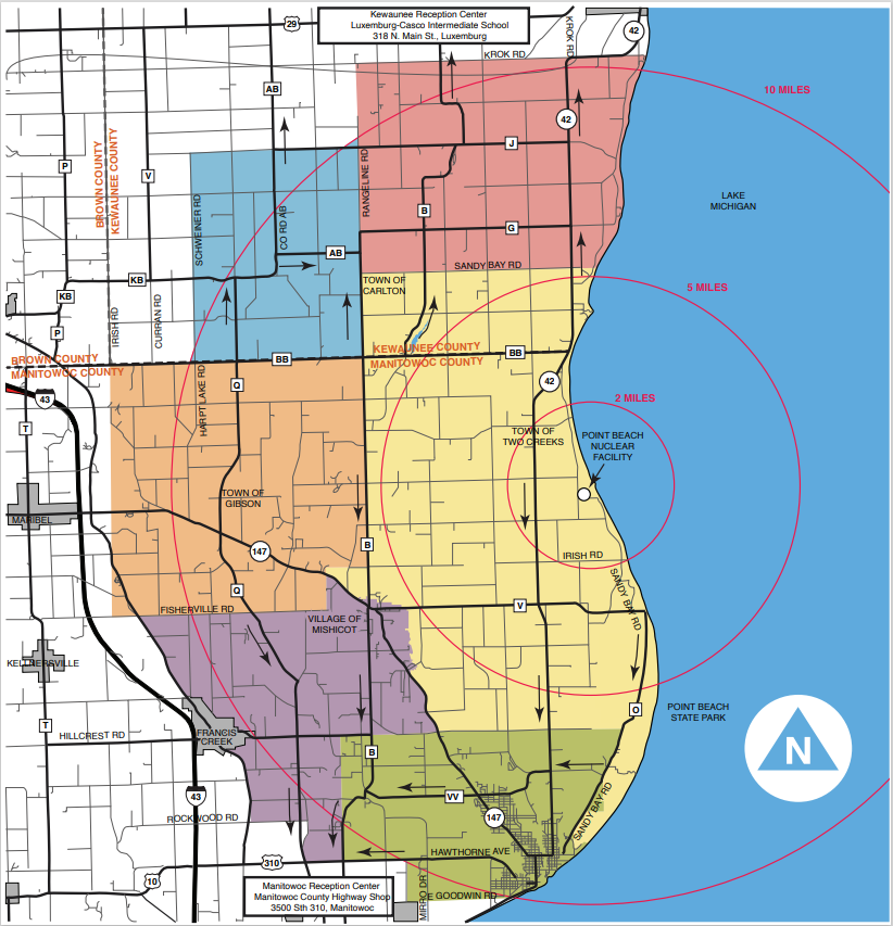
Emergency Planning Maps
Important information to know
To save time and avoid confusion during an emergency, there are a few pieces of information that will help you and your family be prepared. Print out the Important Emergency Information Worksheet and keep it where you will be able to find it when it counts.
Where is your reception center? Several reception centers are available to provide food, shelter, and communications during an emergency. Knowing where your reception center is will help you know where to go if you are directed to evacuate.
What is your best evacuation route? Evacuation routes are outlined on the map and detailed below. Familiarizing yourself with the evacuation route now will help reduce stress during an emergency.
Luxemburg-Casco Intermediate School
318 N. Main Street, Luxemburg, WI 54217
Directions:
- From the City of Kewaunee or Town of Pierce Take State Hwy 42 North to Hwy 54. Take State Hwy 54 west to Heritage Road, south on Main Street, east to Marcks Lane, Luxemburg.
- From the Towns of Montpelier and Franklin Take County Hwy AB north to State Hwy 54. Cross State Hwy 54 east to Marcks Lane, Luxemburg.
- From the Towns of Kewaunee and Carlton Take State Hwy 42 north to State Hwy 54. Cross State Hwy 54 east to Marcks Lane, Luxemburg or take County Hwy B north to County Hwy C. Take County Hwy C north to State Hwy 54. Cross State Hwy 54. Cross State Hwy 54 to west Heritage Road south on Main Street and east on Marcks Lane.
Reception centers are established to monitor evacuees for radiological contamination. Short-term housing and food is provided. Please go to the reception center for monitoring and registration even if you and your family do not need housing.
Manitowoc County Highway Shop
3500 State Hwy 310, Manitowoc, WI
Directions:
- From the City of Two Rivers Take State Hwy 310 west to 3500 State Hwy 310, Manitowoc.
- From Point Beach State Forest Take County Hwy O south to Viceroy Road/County Hwy VV. Take Viceroy Road/County Hwy VV west to County Hwy B in Shoto. Take County Hwy B south to State Hwy 310. Take State Hwy 310 west to 3500 State Hwy 310, Manitowoc.
- From the Towns of Kossuth and Gibson Take County Hwy Q south to State Hwy 310. Take State Hwy 310 west to 3500 State Hwy 310, Manitowoc.
- From the Towns of Two Creeks and Two Rivers Take State Hwy 42 south to County Hwy VV. Take County Hwy VV west to County Hwy B in Shoto. Take County Hwy B south to State Hwy 310. Take State Hwy 310 west to 3500 State Hwy 310, Manitowoc.
- From other areas south of County Hwy BB in Manitowoc County Take State Hwy 42 to County Hwy BB. Take County Hwy BB west to County Hwy Q. Take County Hwy Q south to State Hwy 310 then west to 3500 State Hwy 310, Manitowoc.
- From the Village of Mishicot or Town of Mishicot Take County Hwy B south to State Hwy 310. Take State Hwy 310 west to 3500 State Hwy 310, Manitowoc.
Reception centers are established to monitor evacuees for radiological contamination. Short-term housing and food is provided. Please go to the reception center for monitoring and registration even if you and your family do not need housing.
In the event of an evacuation, emergency transportation will be provided along the evacuation routes for affected areas to those who have no other means of transportation. Contact Manitowoc County Emergency Management (920) 683-4207 or Kewaunee County Emergency Management Agency at (920) 845-9700 to pre-register for evacuation assistance each year.